Trail On foot Gouveia (São Simão) - Trilho dos Caminhos de Água - Photo

Trilho dos Caminhos de Água

Tous les sentiers balisés d’Europe GUIDE+

© OpenStreetMap contributors
Length
Length
10.4 km
Max alt
Max alt
947 m
Uphill gradient
Uphill gradient
272 m
Km-Effort
Km-Effort  
14.1 km
Min alt
Min alt
719 m
Downhill gradient
Downhill gradient
271 m
Boucle
Boucle
Yes
Signpost
Signpost
Creation date :
2022-02-14 14:43:56.716
Updated on :
2022-02-14 14:43:56.716

(0 Reviews)

On foot
On foot
3h11
Difficulty : Easy

Scan this QR Code to open this trail in the SityTrail application

FREE GPS app for hiking

Logo SityTrail SityTrail

IGN / Geographical institutes

Download SityTrail from the App Store Download SityTrail from Google Play

Logo SityTrail SityTrail World

The world is yours!

Download SityTrail from the App Store Download SityTrail from Google Play Download SityTrail on Huawei AppGallery

About

Trail On foot of 10.4 km to be discovered at North, Porto, Gouveia (São Simão). This trail is proposed by SityTrail - itinéraires balisés pédestres.

Elevation profile

Positioning

Country:
Portugal
Region :
North
Department/Province :
Porto
Municipality :
Gouveia (São Simão)
Location:
Unknown
Start:(UTM)
580787 ; 4562649 (29T) N.

Trails nearby

Trail On foot Soalhães - Pedras, Moinhos e Aromas de Santiago - Photo
On foot
GUIDE+

On foot

Easy
Soalhães, North, Porto, Portugal
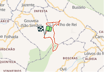
7.6 km | 11 km-effort
2h 30min
No
Trail On foot Campelo e Ovil - Trilho das Florestas Naturais - Photo
On foot
GUIDE+

On foot

Easy
Campelo e Ovil, North, Porto, Portugal
11.9 km | 18.4 km-effort
4h 10min
Yes
Trail On foot Várzea, Aliviada e Folhada - Trilho dos Dólmens - Photo
On foot
GUIDE+

On foot

Easy
Várzea, Aliviada e Folhada, North, Porto, Portugal
11.2 km | 15.1 km-effort
3h 26min
Yes


Close
My subscriptions